Last week I spent a few days traveling to Portland, OR for work,
and while flying home I made the following notes about the landscapes, sights and sounds I
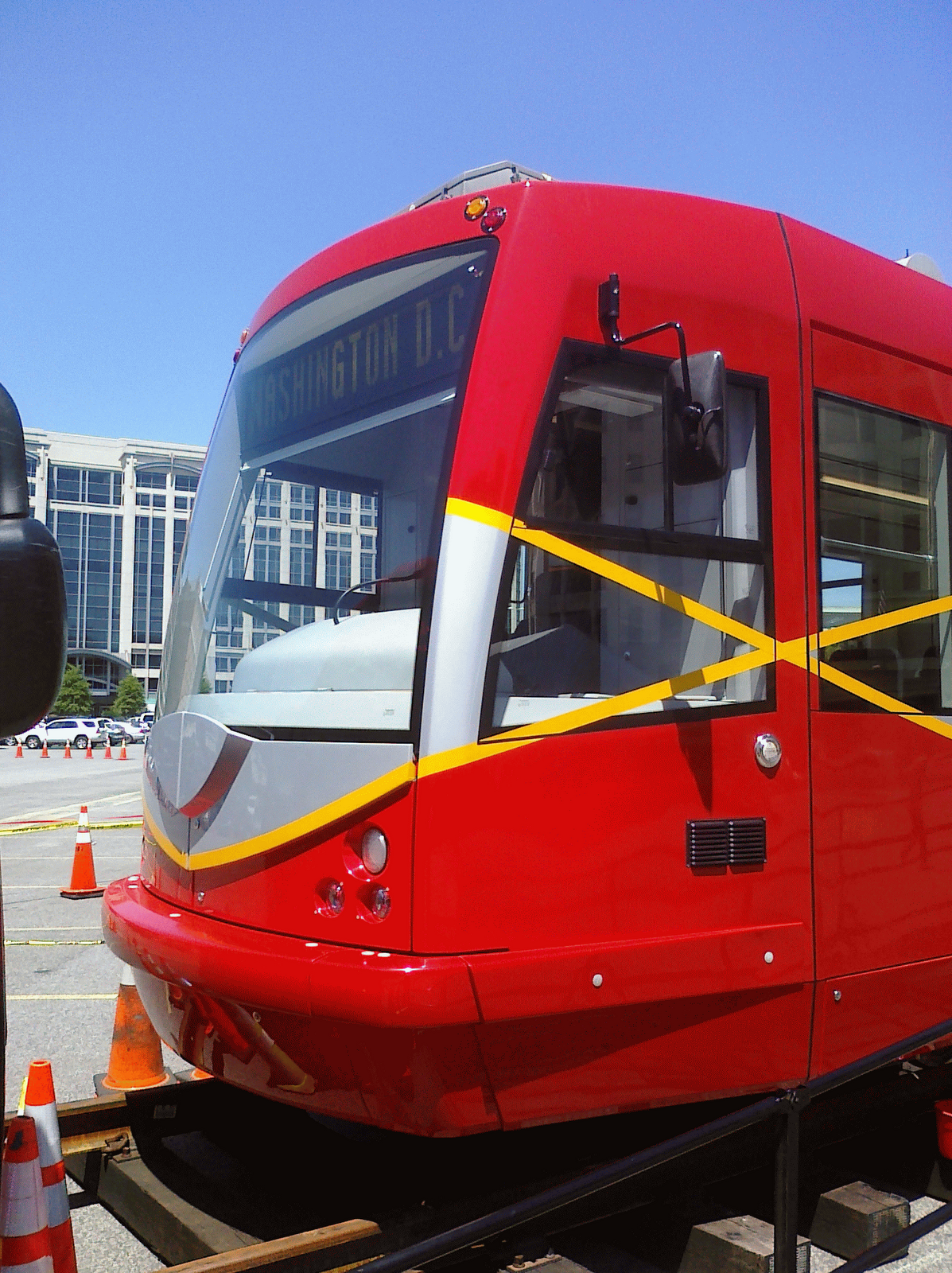
experienced. Highlights of my time in Portland include riding their streetcar system. Here are my notes:
Flying over the Rockies on the way to Phoenix (where home prices have fallen 35% since last year, per this morning's complimentary "USA Today"), below me are brown mounds with snow-capped peaks. Less snow than there should be? As far as eyes see, all looks very dry - despite the
gullies obviously caused by running water at some point in the past, there is precious little in evidence today. Perhaps that is Utah down there - large white salt flats. Dry as bone, looking for all the world like the dried-up ponds of Mars. Range after range, ridge after ridge. Large crop circles arranged in four-square grids, or offset, all touching at tangents.
Another brown valley, another salty dried pond in varying shades from white to mocha. Here a few scrubby trees dot the lower
hills, and dirt roads, from up here only hair-thin pinstripes of tan where the cars go. Besides those roads, remarkably few signs of man. Very few buildings. Man tries to impose orderly grids here, and mostly fails - God's hand shaped these dry hills into water-formed rolling hills, curves, not straight lines. And man's
agri-grids are of shades of green
abbreviated where God's work intervenes. This land is owned, but not conquered. It looks like the kind of place where men die from exposure and lack of water. Looks like it should be called things like "Deadwood" or "
Tombstone".
Yet another dry, flat valley floor in Starbucks technicolor. Humanity's tenuous straight lines await the next deluge to be washed away. Where there is more evidence of people, small airports and angular cut-lines appear showing where trees were harvested, roads and grids defining places.
Occasionally a gradual transition to more green, higher elevation, much more alpine with trees.
Now an open pit mine, terraced, consumes a hill and Yes! there's a colored pond. But is it a pond of slag and
tailings, colored green by the remnants of copper mining? A larger range comes into view which looks like it could support skiing right now. Still no creeks, rivers, or ponds. Range after range, valley after valley. A patch of green trees or shrubs looking for all the world like a B-2 stealth bomber, its straight-lined leading edges clearly the work of man. Did some
aerospace engineer see this formation years ago and conclude "that looks like a nice shape for a plane"? Where is the benevolent hand of man? Why do our works always mar the canvas created by the Almighty? Clearly we are incapable of improving on His
handiwork. But why then can't we just leave it alone?
Dry and clear skies, no clouds. On a hill below, a few dabs of copper among the taupe - old sites where we dug something up, I think, but so long ago the holes are long filled and not obvious. Power lines, roads intersect - creek beds and dried rivers merge. Two huge squares where trees removed make the valley look like a quilt. Denuded highlands therein are divided by vales of darker green, where trees must be smaller or harder to cut, perhaps less valuable. The land continues to green, and the grid ever more forcefully elbows out the hand of the Creator. But the dry timeless landscape fights back
valiantly.
A pond! And another. Oh, more mines....
Now, very impressive valleys, sides marked by rock strata, exposed by rivers that appear to be long gone, replaced with dirt roads. A VERY impressive flat plateau with a fascinating rock wall bridging a valley at one end - looking like God's version of the Hoover Dam. A tiny, rusty red town appears, shiny metal roofs in a grid. A tiny "X" marks the spot where an airstrip stands.
Flying to Phoenix in low-earth orbit.
Next, a mini-Grand Canyon. Where is the mini-Evil
Knievel trying to jump his way into mini-history books? More and more the rust peeks through the tan. Now a NOT so mini-Grand Canyon. This must be the real one. Very deep, piles of eroded sandstone filling the valleys, smoothing them. Strata exposed, layers made by nature's own
stereolithography machine. Deep gouges. Green stipples, tiny pin-points that color and define the rivulet beds and
gullies.
As we approach Phoenix, the city lies in a broad flat plain, punctured only by the
occasional rock formation. Otherwise this is a vast sea of suburban sprawl with an ever so cute "downtown", two small clusters of
verticality with a few dozen tallish buildings, plus a basilica that appears to be the home of the Diamondbacks. Confirmed on the flight out, the retractable roof open and a game in progress.
THIS is the definition of sprawl.
You can distinguish the richer neighborhoods from the poorer by color, even at this altitude. Poorest places are the orange-tan of the desert, richest the incongruous lushness of green.
Cul-
de-sacs! Endless plane of single-family houses.
I loved the desert - but from what I saw from the air, I don't much care for Phoenix.
*****
Thanks to a fairly busy work schedule and a tight itinerary, I only had a few hours to experience downtown Portland, but my brief visit left me impressed. On Wednesday evening, after a day full of meetings south of town, I took the Max train from my airport hotel, past the Rose Garden (eerily quiet outdoors while the Trailblazers staved off playoff elimination inside). The ride reminded me of trams in Riga, despite the distance (10K miles and 10 years). I think the damp,
chilly weather helped, too. Thankfully my free evening had relatively pleasant w
eather, the day's downpour having mostly subsided to overcast mistiness and 55 degrees. The air was clean in a way I haven't experienced in a long time, a pleasant gift to 40-year-old lungs.
A nice dinner of
steelhead washed down with
bourbon and coke, followed by a stroll around the city. Some nice
architecture, a good bit of construction and a large homeless population. Enjoyed Courthouse Pioneer Square, had a local
micro brew, and took a cab back to the hotel. My cab driver was Armenian, here for 12 years with his family. Lives in Vancouver, WA as it is cheaper and safer than in Portland proper, in his view.
Despite the late nights, my body was clearly still on East Coast time, as I had no problem waking up at 6am PT.
******
More observations from the plane windows:
Now heading east from
PHX to DC. Initially the terrain was greener than before, with more trees. Now that has changed again to a rather flat plateau, dotted with mesas (which I had never seen before). Very little vegetation, just flat, white-to-red desert (my seat-mate says it's copper). Still very barren with lots more dry rivers.
The big round crop circles are back in force, more varied in size and arrangement. Red, orange and green dots, half-rounds, and
Pac-Men. The terrain has turned greener and more rugged, yet again, this time with a large zone of natural gas wells pock-marking the hills for miles. Passed a couple huge, sheer cliffs. More evidence of man and water is visible here, but the
landscape is preparing to change again - to the north (on the other side of the plane) is a huge area of rugged, snow-capped mountains. The terrain to the south has also returned to snow-capped peaks, though not as dramatic as those to the north.
Evidence of ever-increasing altitude. A couple
massive peaks standing alone with white tops. It is very clear where the water is - farms and settlements closely trace the lines of the larger rivers and streams (or even their dried-up beds).
Now the landscape has flattened again - no hills in sight, and the vast plain is a quilt of green and tan squares. Lots of crop circles in multiple colors that resemble pie charts. Interesting figure/ground reversal on some crop circles: tan circles surrounded by voids of green. The unmistakable
graining of contour farming was evident in places.
Flying close by a huge fluffy white
cumulus cloud reaching towards the
stratosphere, its top blown flat into the characteristic anvil shape as the high-speed
stratospheric wins catch the top layers of moisture.
The landscape continues to grow greener as we work our way east. Now there are actual rivers with actual water in them, green grass, fields and trees. With the greenery and moisture comes the clouds, and soon I cannot see the ground at all.
Now it's night, and we emerge from the clouds (having allegedly passed over Chicago, completely cloaked in vapor). There are cities below us, lit by excessive light, and we are somewhere over OH/PA/MD at this point, with half an hour until touchdown. Why don't we have those great maps on this flight showing our position along the flight path? The bourbon and coke has relaxed me to the point of wanting a nap, mellow enough to glide out of National Airport to the Metro and home to Cleveland Park. It's been a productive trip and I enjoyed it very much. Hope to see Portland again some day.