In May, when the economy was heading into the ditch at blistering speed and the automakers were struggling to shrink themselves to prosperity, I wrote a post and published a graphic on what the major players in the U.S. auto market might look like once the dust settles.
Now the folks at Mint.com have put together a similar graphic here. Theirs focuses exclusively on the U.S. "Big Three", as opposed to mine which was a broader look at the industry's reorganization.
Not much new info here, but I have to give them props for the fancy presentation. Enjoy!
Thursday, September 10, 2009
Thursday, August 27, 2009
Once More, With Feeling
Time to wrap up my coverage of the classic car show at the Howard County Fair with a quick blast of photos representing my personal "Best In Show."
 First of several Corvettes - this red one is from the '60s...
 ... and THIS red one is from the '50s (maybe '58).


 Somebody spent a ton of cash on this highly-modified Studebaker Golden Hawk. Gorgeous. Not subtle.
 A moment of silence, please, as we pay our respects to the Plymouth brand, God rest her soul. Still flying the flag.
 "Goodnight, Jim Bob."
 A prop from "Driving Miss Daisy"?

THE PICKUP COLLECTION
THE ROADSTER COLLECTION
First, a gorgeous black Porsche. I'll take one in black and another in red, please.
 First of several Corvettes - this red one is from the '60s...
 ... and THIS red one is from the '50s (maybe '58).
This 'Vette is a couple years older still, a '55 or '56, the first generation. Note that the quad headlights from the red 'Vette above debuted on many GM models in 1958.

THE PONY CAR & SEDAN COLLECTION
Always competing, even when parked in a field with the bonnet up. Here a Camaro SS and a Mustang show us what's under the hood.
 Somebody spent a ton of cash on this highly-modified Studebaker Golden Hawk. Gorgeous. Not subtle.
 A moment of silence, please, as we pay our respects to the Plymouth brand, God rest her soul. Still flying the flag.
 "Goodnight, Jim Bob."
"Goodnight, John Boy."
 A prop from "Driving Miss Daisy"?
THE PICKUP COLLECTION
This gorgeous green Chevy reminds me of a Stepside my younger brother had back in the '90s. Much like my old Caprice, I'm sure he'd love to have that truck back now. I'd love to have this one myself.

 Next I found a two-tone Ford, a Fleetside restored to within an inch of its life. My uncle, a plumber in North Carolina, had a more pedestrian monotone example very much like this one.
 This one I wanted to drive home that afternoon. One thing was clear at this show: many of these car collectors have a ton of cash to spend on restorations, chrome engine treatments, custom paint jobs and interiors, etc. Recession? What recession?!
 Finally, a great old Chevy stepside with side-mounted spare, next to a fabulous fifties Ford with a power retractable hardtop. Nice!
 Hope you enjoyed the pics. Odds are I'll hit another show this fall, and I pledge to remember to bring a REAL camera next time so that I don't have to rely on the single-use, drug-store specials...

Stepping back in time a decade or two, we find this immaculately-restored Ford, another Stepside.
 Next I found a two-tone Ford, a Fleetside restored to within an inch of its life. My uncle, a plumber in North Carolina, had a more pedestrian monotone example very much like this one.
 This one I wanted to drive home that afternoon. One thing was clear at this show: many of these car collectors have a ton of cash to spend on restorations, chrome engine treatments, custom paint jobs and interiors, etc. Recession? What recession?!
 Finally, a great old Chevy stepside with side-mounted spare, next to a fabulous fifties Ford with a power retractable hardtop. Nice!
 Hope you enjoyed the pics. Odds are I'll hit another show this fall, and I pledge to remember to bring a REAL camera next time so that I don't have to rely on the single-use, drug-store specials...
 More Classic Iron
Among the other fabulous cars I saw at the Howard County Fair a couple weekends ago was this lovely back number. Love this freakin' hearse. Check out the custom coachwork, including side panels that look like curtains. At first glance I thought they were some sort of plastic do-dads added in the 70s - but it's actually STEEL, people! The owner had photos of the unrestored car with rust covering those drapery panels. I've never seen anything like it - a real looker.

Below is a gorgeous 1940 Buick. The sign says "96 produced. This is allegedly the extant version with dual side mounts." So this one might be worth some bank.

Also of interest to me, thanks to my Mopar jones, was a gorgeous Chrysler Imperial. A few shots - check out the fabulous tail-lights, and the headlights-on-stalks. Car also had a push-button automatic transmission (which makes an enormous amount of sense, when you think about it). Some fascinating details.


More cars to come in my next post. Stay tuned!
Monday, August 24, 2009
Classic Car Show at the Howard Country Fair
I found my grandfather's car at the

Howard County Fair auto show a couple weeks ago. OK, not EXACTLY my grandfather's car, but a twin sister. On what had to be one of the hottest days of 2009 (and brightest, judging by my over-exposed photos), I drove up to the fairgrounds to have a gander at the antique machinery.
And there it was: a 1973 Chevrolet Caprice, a near twin of the burgundy Classic I bought from my grandfather in 1992. To this day, I wish I hadn't sold that cherry ride. Burgundy paint, black vinyl hard top, immaculate burgundy cloth interior, pillarless doors, and a honking V-8. Nice.
The green and white example at the fair was a real looker, too, in excellent condition. I had a nice chat with its owner, a delightful older gentleman who's owned the car for 40 years.
Here are a couple more images of that fabulous ride that brought back a lot of memories.


Stay tuned for more images from the show - lots of nice iron.
Saturday, August 1, 2009
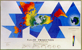
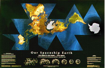
The Dymaxion Map & Geodesic Dome
Two of Bucky Fuller's Many Innovations

While researching my prior post on The Buckminster Fuller Challenge, I ran across another of Fuller's innovations, the Dymaxion Map. It's a fascinating application of Fuller's folded-triangle geometric principles. These principles also generated the geodesic dome, of which Epcot Center is probably the most famous example:

Below is a geodesic dome designed by Fuller in 1967 for The Bioshere, a water and environment museum in Montreal:

Below are a couple more examples, showing the triangular sections and how they fit together to form a 2-dimensional representation of the 3-dimensional earth.
If you're interested in learning more about the works of Fuller, his life and innovations, this website offers books, posters, and more. Enjoy!

2009 Bucky Fuller Challenge Winner

"Does humanity have a chance to survive lastingly and successfully on planet Earth, and if so, how?"
Legendary designer and futurist Richard Buckminster “Bucky” Fuller (1895-1983) was concerned with this question throughout his life. His inventions and innovations focused on ways to minimize our impact on this earth while maximizing human potential.
Every year, the non-profit Buckminster Fuller Institute conducts a contest (the Buckminster Fuller Challenge) and awards a $100,000 prize "to support the development and implementation of a strategy that has significant potential to solve humanity’s most pressing problems." The winner of the 2009 Challenge is the Smart Cities Group at the MIT Media lab, for their entry entitled "Sustainable Personal Mobility and Mobility-on-Demand Systems", which is a system of sharing 2- and 4-wheel vehicles in an urban setting. The innovative proposal includes a collapsable 2-wheel "RoboScooter" and stackable 4-wheeled "CityCar." Excerpted from the winning proposal:
"Mobility-on-Demand systems utilize fleets of shared-use lightweight electric vehicles placed at automatic charging racks throughout a city. The CityCar and RoboScooter, both folding vehicles, along with the Green-Wheel Bicycle, minimize parking space and can be picked-up and dropped-off at any rack. Mobility-on-Demand systems maximize mobility and dramatically reduce congestion and pollution through energy and land-use efficiency."
Details of the proposal, and those of other contest entries, can be found here.
Friday, July 24, 2009
Quick Shout-Out to "The Examiner" for Smart Growth Article
Readers of this blog know that I am no huge fan of the free weekday DC tabloid "The Examiner", due to its irritatingly right-wing editorial slant. In fact, practically every week I say to myself "I am never reading that right-wing nut-job propaganda organ again."
However, I have to give credit where credit is due. Say what you will about the intellectual integrity of the paper's editorial rants against the President and Democrats: but the paper does the best job in town of covering traffic, commuting and development issues. Witness this article in yesterday's "Examiner" on smart growth. Here are a few excerpts:
Organizations like the Coalition for Smarter Growth are lobbying for transit projects that shy away from highway expansion and to focus more on encouraging development around transit hubs.
Stewart Schwartz, executive director of the coalition, said that rather than widening lanes and building high-occupancy toll lanes, officials should examine charging peak rates for using existing lanes during rush hour, as Metro does.
The coalition was one of several groups that rallied against a Montgomery County plan this week to widen Interstate 270.
"We urge the County Council to reject the Planning Board's misguided transportation recommendations, the result of which would be more cars on the highways and more traffic jams," said Ben Ross, president of Action Committee for Transit, a Montgomery County citizens group.
***
Schwartz said the key was to adopt a model similar to Arlington County or Old Town Alexandria, namely, focusing development near rail stations and transit centers.
So, props to "The Examiner" - here's hoping they will continue to cover these very important issues in a "fair and balanced" manner.
Tuesday, July 21, 2009
My Post on CNN.com's "Cafferty File"
 In his blog post today on CNN.com, Jack Cafferty discusses the increasingly dire state of federal and state finances. With tax revenues in free-fall, and demands for government services spiking, he correctly points out that something's gotta give. You have basically three options in this situation:
1) Debt - put it all on the credit card (although we've just about maxed-out our credit card from the Bank of China);
2) Raise Taxes (always unpopular); or
3) Cut Government Spending and Services (also unpopular).
So what's a government to do? Here's my take, posted today:
It’s truly time to re-evaluate our priorities, and here are a few things I would do if I were Obama-for-a-Day:
1) Eliminate agriculture subsidies, which encourage overproduction and distort overseas food markets (destroying local production abroad, esp. in developing countries).
2) In accord with 1 above – Eliminate subsidies for corn-based ethanol. If we are to go down the road of renewable fuels, they cannot be based on food crops. Better to go the Brazilian way of switch grass or agricultural waste as feedstocks.
3) Increase gasoline taxes to $1 per gallon, and tilt the balance of transport spending away from ever-larger roads, and towards mass transit. I am thoroughly convinced that GM and Chrysler cannot compete in a world of $2 gasoline – the market will never buy the smaller, more fuel efficient vehicles that new owner Uncle Sam wants them to produce, until people have a reason to buy them. Tax gas to reduce environmental pollution, reduce our dependence on imported oil, and then shift transport spending from autos to mass transit, which will give people viable alternatives to driving. If you focus on nothing but automobiles for over 50 years, as we have done here, and you get nothing but more and more auto-induced sprawl and gridlock – how can you be surprised by that outcome?
4) We need to take a good, hard look at the entitlement programs which are sinking our budgets, in particular Social Security and Medicare/Medicaid. We’re going to need means testing for all three programs, and higher retirement ages for SS. It makes little sense to subsidize the wealthiest demographic (retirees) by taxing the poorer demographics.
5) Require the Federal Government to operate under a balanced budget except in times of military conflict, and even then require a two-thirds majority of the SENATE (not the hopeless, parochial House) to approve deficit spending. We are drowning in red ink, and we must begin living within our means.
And while we’re at it: let’s abolish congressional districts for individual states and go to a national, party-based proportional representation system. A Congress tied to individual states has demonstrated that it cannot be trusted with the power of the purse.
6) If we can’t get to a balanced budget by using the ideas above (and there’s no way these steps will be enough), then we’ll need across-the-board reductions in ALL government operations: tell each agency they need to lose their dead wood. As someone with a wife employed by Uncle Sam, let me assure you that 5% of federal staff could be eliminated without affecting services provided! The kind of dysfunction tolerated in government bureaucracies is astounding, and it’s time we created incentives to root out waste. No more free-riders, no more coddling of dead-wood by the nanny-state and employee unions.
Thanks for allowing the rant, Jack!
Sunday, June 7, 2009
A gorgeous afternoon biking along the Potomac, the new Wilson Bridge, and National Harbor
 This afternoon I went for a bike ride down the Mount Vernon Trail along the Potomac, with the ultimate goal of exploring the newly-openend bike path on the Woodrow Wilson Bridge. As I always do, I started on Rock Creek Park, biked through Georgetown, passed the Kennedy Center, across Memorial Bridge and down to the Mount Vernon Trail.
On the Alexandria side of Wilson Bridge, I passed a lovely cemetery and vegetable garden, though Virginia has a lot of work to do around the base of the bridge to undue construction fencing and ugly paved lots that were used as staging space and is now vacant. Once on the bridge, I stopped to enjoy the fantastic views of Alexandria and the U.S. Capitol from the span, reading the tourist placards at three or four bump-out "overlooks" facing north. A signature feature of the bridge is a gorgeous, streamlined "control tower" of glass and stainless steel. Once on the Maryland side, I was impressed by the significant amount of landscaping - and seriously have to wonder how dedicated Maryland is to maintaining all of the fabulous plantings (trees and ground cover), landscaping mulch, as well as acres of brick pavers.
Continuing on the path, I discovered that it wound around to the south all the way to National Harbor, so I decided to take a look. Again, a very nice execution (though some finishing touches remain) - and I wondered again who will pick up the trash that washes up on the riverbanks along the bike path, as well as maintaining the white crushed seashells that comprise the trail once you enter the Harbor property.
Cute detail: there was a carved wooden bench on the Harbor property including two large turtles on the seat. Later, I would spot a real turtle sunning himself on a stump protruding from the shallow Potomac, about 20 yards offshore.
National Harbor was busy with people on this day thanks to the Food and Wine Festival. With all the little shops and hotels, the complex struck me as a larger version Pentagon Row, with boats. I hope the site is successful, as the community has much invested in its success. May I live long enough to see a streetcar from DC out to National Harbor and across the bridge to Alexandria. Preferably with a significant contribution from those who decided to build this thing where it can only be reached by car - and now bike.
The bridge impressed me as the kind of public works project this country used to build routinely: large, modern, beautifully designed, functional. The "V" motif of the massive piers can also be read as the middle of an even larger "M": perhaps a nod to the two states connected by the bridge.

On the way back to DC, I passed more wildlife: a large floating gaggle of geese in Old Town, an armada floating on the river, black necks straight skyward like masts. Soon after I passed National Airport, I spotted movement at the side of the trail which turned out to be a large black snake, 5-6 feet long. I stopped and shooed it off the trail, back into the brush at the water's edge, so that no one would be hurt or startled by it (though in truth I was more concerned that some macho idiot would do it harm).
Love the sun, love the trail, love the Potomac, even love the geese, snakes, and that huge white bridge.
Look Hoos Going to Omaha! Congratulations to the Cavalier's Baseball Team!
 This afternoon, the University of Virginia's baseball team defeated Ole Miss on their home field in Oxford, Miss, taking the NCAA Super-Regional two games to one, and paving the way for Virginia's FIRST EVER trip to the College World Series in Omaha!
Congratulations to this gritty team, which seems to be peaking at precisely the right moment, and to the coach who rescued UVA baseball from the grave, Brian O'Connor!
Good luck in Omaha, fellas!
Monday, June 1, 2009
Saying "I told you so" is pretty immature - which never stopped Michael Moore in the past...
I was quite curious to find out the level of glee and gusto with which Michael Moore would rub salt into GM's wounds as he discusses his prescription for the auto giant's future in today's The Daily Kos. On the contrary, I was surprised by how gracious he was: while pointing out many of the General's failures over the years, he did not dance on GM's grave.
While a good hunk of what Moore suggests for the future of GM is pie-in-the-sky stuff, I agree with his basic premise: saving GM for the purpose of building more crappy cars does not serve America's long term interests. Those interests, however, could indeed be served by using this opportunity to re-purpose GM and its laid-off workers, putting them in service of a greener economy by building trains, solar and wind power equipment, etc. I particularly enjoyed this part of Moore's article:
[Let's announce] that we will have bullet trains criss-crossing this country in the next five years. Japan is celebrating the 45th anniversary of its first bullet train this year. Now they have dozens of them. Average speed: 165 mph. Average time a train is late: under 30 seconds. They have had these high speed trains for nearly five decades -- and we don't even have one! The fact that the technology already exists for us to go from New York to L.A. in 17 hours by train, and that we haven't used it, is criminal. Let's hire the unemployed to build the new high speed lines all over the country. Chicago to Detroit in less than two hours. Miami to DC in under 7 hours. Denver to Dallas in five and a half. This can be done and done now.
You can read Moore's full article here.
Sunday, May 31, 2009
Requiem for the General: My GM Ownership Experience
 The New York Times' autoblog "Wheels" is running a post sharing the author's experiences with GM cars, on the occasion of the car-maker's imminent bankruptcy filing on Monday. And he invites readers to do the same. So read his story, and post your own, here.
Although I grew up in a purely Ford and Chevy household (mostly pickups), my only GM car ownership experience to date is a '73 Chevy Caprice, purchased from my grandfather for $500 just before his death in the early '90s. Car was in great condition inside and out, had a pre-smog-control motor that would haul you-know-what. That car made several long trips up and down the eastern seaboard, and was a joy to pilot down the roads, even if it was impossible to keep gas in it or to find a parking spot big enough for it. Did burn a little oil, and the A/C self-destructed the first time I tried to use it, but then again it WAS 20 years old by the time I got my hands on it.
A few years later I moved to Rochester, NY in the frozen north and had to liquidate the Chevy for a more-practical front wheel drive vehicle (a Ford Tempo of all things - what a come-down). But I'd give my eye teeth to have that burgundy over burgundy beauty (with black hard top) back in the garage as my "toy" car.
My garage has been graced over the years with the following collection of steeds:
- 1975 Mercury Comet: Yellow paint, White hard top, Pea Green interior (with a flatulent exhaust note reminiscent of a UPS truck)
- 1978 Mercury Zephyr: Light Tan paint, Dark Tan interior
- 1973 Chevrolet Caprice (see above)
- 1986 Ford Tempo LX: Medium Blue Paint and interior
- 1995 Plymouth Neon: Lilac paint, Grey interior (my first New car)
- 1991 Ford Escort wagon: Electric Blue paint, tan interior (built by Mazda; damned transmission!)
- 2000 Dodge Stratus ES: Light Cyprus Pearl Coat paint, Dark Charcoal interior
- And currently a 1999 Honda CR-V: Silver paint, Grey interior
While GM has produced precious few vehicles that I have considered purchasing during my adult lifetime, I do hope the company can resurrect itself and continue as a going concern. It will be an enormous loss to this country if our ability to manufacture cars slips away in much the same fashion as TVs, radios, VCRs, computers, etc., etc.
Happy Motoring!
Wednesday, May 27, 2009
Brand Shuffling in the U.S. auto market: You can't tell the players without a scorecard.
 Although I have become a rather serious proponent of public transportation over the years, especially for urban environments, I have been and remain an enthusiastic car buff. There was a time when I looked forward each month to the arrival of "Car & Driver" and "Automobile" magazines, and I would sometimes read them cover to cover in one sitting. To learn more about the industry, I even worked for a brief time in my twenties as a salesman in a Chrysler-Dodge-Subaru dealership (can you say "fundamental type mismatch"?).
And while I no longer follow the industry as I did in those years, I retain a strong interest in the doings of the industry: new models, corporate mergers and partnerships, the latest technological advances, personalities and market forces that shape the industry, etc.
There has been much to digest over the last several months, to say the least.
The landscape that appears likely to emerge from the current economic tsunami will bear little resemblence to the status quo. The entire automotive order is being reshuffled, and the big players in the American automotive market will take on an ever more international flavor.
This is ultimately a good thing - America's "Big 3" long ago surrendered their prior leadership roles in automotive innovation to their German, Japanese and Korean counterparts. Can the Chinese and Indians, both with ambitious plans to crack the U.S. auto market, be far behind?
When I was a child the automotive powers of the American marketplace looked like this:
- General Motors
- Ford
- Chrysler
- Volkswagen
- Toyota
- Honda
- Nissan
Beginning in the 1980s and continuing to the present day, the Japanese manufacturers developed reputations for building reliable, efficient cars, and moved their vehicles up the ladder of sophistication and luxury to become full-line brands, offering vehicles from small to large, from cars to trucks, minivans and SUVs, from thrifty to luxurious. The Germans continued to supply high-end cars, moving up to the luxurious end of the spectrum once occupied by Cadillac, Lincoln, and Buick. Currently, the Koreans (Hyundai, Kia) are following the path of their Japanese predecessors, expanding their overall product portfolio while moving away from cheap econoboxes towards near-luxury sedans, minivans, and SUVs.
The one constant has been a persistant loss of market share by Detroit's Big 3 to the "newcomers" (remember when they were almost derisively referred to as "imports"?). Over time, the Japanese, German and now Korean manufacturers even added manufacturing plants here in the U.S.A. employing tens of thousands of American workers.
I created the the graphic above to represent what the landscape may look like once the dust of the current crisis settles. Highlights include:
- Chrysler as a homeless vagabond, being passed from one foreign corporate master (Daimler-Benz, 1998-2007) to another (Fiat), after a brief period of independence (2007-2009). Hmm... Sounds like Latvia between the wars....
- GM and Ford shedding Asian and European subsidiaries in a rush to streamline. Ford got a head start when it flirted with bankruptcy a few years ago, cutting its close ties to Kia, Jaguar and Land Rover, and currently seeking to divest itself of Mazda and Volvo. GM, meanwhile, appears to be the largest victim of the economic slowdown, and will emerge a much smaller company as it struggles to survive. It has shuttered Oldsmobile and Pontiac for good and now seeks to sell off Saturn, Opel/Vauxhall (GM Europe), Hummer, and Saab.
- Fiat may return to the U.S. market and emerge as one of the world's largest automakers if it can pull off the acquisitions of Chrysler and Opel/Vauxhall.
- Volkswagen continues to absorb its purchase of U.K. super-lux brand Bentley while it works on a merger with Porsche.
- Similarly, BMW has expanded its U.S. presence by picking up the Rolls-Royce and Mini (Cooper) brands.
- Meanwhile, the availability of the Saturn brand and distribution channel is attracting lots of attention from investor groups and foreign automakers, including Chinese and Indian companies looking for access to the U.S. marketplace. Saturn's 384 dealerships offer that access on a turn-key basis. Investor groups hoping to facilitate that access are lining up plans to buy the chain as we speak.
- Meanwhile, look for aggressive marketing from titans Toyota, Honda, Nissan-Renault, Hyundai-Kia (as well as smaller players like Subaru and India's Tata, which owns Jaguar and Land Rover) to pick up market share as the industry adjusts to the seismic shifts noted above.
One thing is sure: more of the old, familiar auto brands will disappear, and be replaced by new brands with decidedly foreign pedigrees.
Friday, May 1, 2009
PDX to PHX: Flying to Phoenix in low-earth orbit
 Last week I spent a few days traveling to Portland, OR for work, and while flying home I made the following notes about the landscapes, sights and sounds I experienced. Highlights of my time in Portland include riding their streetcar system. Here are my notes:
Flying over the Rockies on the way to Phoenix (where home prices have fallen 35% since last year, per this morning's complimentary "USA Today"), below me are brown mounds with snow-capped peaks. Less snow than there should be? As far as eyes see, all looks very dry - despite the gullies obviously caused by running water at some point in the past, there is precious little in evidence today. Perhaps that is Utah down there - large white salt flats. Dry as bone, looking for all the world like the dried-up ponds of Mars. Range after range, ridge after ridge. Large crop circles arranged in four-square grids, or offset, all touching at tangents.
Another brown valley, another salty dried pond in varying shades from white to mocha. Here a few scrubby trees dot the lower hills, and dirt roads, from up here only hair-thin pinstripes of tan where the cars go. Besides those roads, remarkably few signs of man. Very few buildings. Man tries to impose orderly grids here, and mostly fails - God's hand shaped these dry hills into water-formed rolling hills, curves, not straight lines. And man's agri-grids are of shades of green abbreviated where God's work intervenes. This land is owned, but not conquered. It looks like the kind of place where men die from exposure and lack of water. Looks like it should be called things like "Deadwood" or "Tombstone".
Yet another dry, flat valley floor in Starbucks technicolor. Humanity's tenuous straight lines await the next deluge to be washed away. Where there is more evidence of people, small airports and angular cut-lines appear showing where trees were harvested, roads and grids defining places. Occasionally a gradual transition to more green, higher elevation, much more alpine with trees.
Now an open pit mine, terraced, consumes a hill and Yes! there's a colored pond. But is it a pond of slag and tailings, colored green by the remnants of copper mining? A larger range comes into view which looks like it could support skiing right now. Still no creeks, rivers, or ponds. Range after range, valley after valley. A patch of green trees or shrubs looking for all the world like a B-2 stealth bomber, its straight-lined leading edges clearly the work of man. Did some aerospace engineer see this formation years ago and conclude "that looks like a nice shape for a plane"? Where is the benevolent hand of man? Why do our works always mar the canvas created by the Almighty? Clearly we are incapable of improving on His handiwork. But why then can't we just leave it alone?
Dry and clear skies, no clouds. On a hill below, a few dabs of copper among the taupe - old sites where we dug something up, I think, but so long ago the holes are long filled and not obvious. Power lines, roads intersect - creek beds and dried rivers merge. Two huge squares where trees removed make the valley look like a quilt. Denuded highlands therein are divided by vales of darker green, where trees must be smaller or harder to cut, perhaps less valuable. The land continues to green, and the grid ever more forcefully elbows out the hand of the Creator. But the dry timeless landscape fights back valiantly.
A pond! And another. Oh, more mines....
Now, very impressive valleys, sides marked by rock strata, exposed by rivers that appear to be long gone, replaced with dirt roads. A VERY impressive flat plateau with a fascinating rock wall bridging a valley at one end - looking like God's version of the Hoover Dam. A tiny, rusty red town appears, shiny metal roofs in a grid. A tiny "X" marks the spot where an airstrip stands.
Flying to Phoenix in low-earth orbit.
Next, a mini-Grand Canyon. Where is the mini-Evil Knievel trying to jump his way into mini-history books? More and more the rust peeks through the tan. Now a NOT so mini-Grand Canyon. This must be the real one. Very deep, piles of eroded sandstone filling the valleys, smoothing them. Strata exposed, layers made by nature's own stereolithography machine. Deep gouges. Green stipples, tiny pin-points that color and define the rivulet beds and gullies.
As we approach Phoenix, the city lies in a broad flat plain, punctured only by the occasional rock formation. Otherwise this is a vast sea of suburban sprawl with an ever so cute "downtown", two small clusters of verticality with a few dozen tallish buildings, plus a basilica that appears to be the home of the Diamondbacks. Confirmed on the flight out, the retractable roof open and a game in progress.
THIS is the definition of sprawl.
You can distinguish the richer neighborhoods from the poorer by color, even at this altitude. Poorest places are the orange-tan of the desert, richest the incongruous lushness of green. Cul-de-sacs! Endless plane of single-family houses.
I loved the desert - but from what I saw from the air, I don't much care for Phoenix.
*****
Thanks to a fairly busy work schedule and a tight itinerary, I only had a few hours to experience downtown Portland, but my brief visit left me impressed. On Wednesday evening, after a day full of meetings south of town, I took the Max train from my airport hotel, past the Rose Garden (eerily quiet outdoors while the Trailblazers staved off playoff elimination inside). The ride reminded me of trams in Riga, despite the distance (10K miles and 10 years). I think the damp, chilly weather helped, too. Thankfully my free evening had relatively pleasant weather, the day's downpour having mostly subsided to overcast mistiness and 55 degrees. The air was clean in a way I haven't experienced in a long time, a pleasant gift to 40-year-old lungs.
A nice dinner of steelhead washed down with bourbon and coke, followed by a stroll around the city. Some nice architecture, a good bit of construction and a large homeless population. Enjoyed Courthouse Pioneer Square, had a local micro brew, and took a cab back to the hotel. My cab driver was Armenian, here for 12 years with his family. Lives in Vancouver, WA as it is cheaper and safer than in Portland proper, in his view.
Despite the late nights, my body was clearly still on East Coast time, as I had no problem waking up at 6am PT.
******
More observations from the plane windows:
Now heading east from PHX to DC. Initially the terrain was greener than before, with more trees. Now that has changed again to a rather flat plateau, dotted with mesas (which I had never seen before). Very little vegetation, just flat, white-to-red desert (my seat-mate says it's copper). Still very barren with lots more dry rivers.
The big round crop circles are back in force, more varied in size and arrangement. Red, orange and green dots, half-rounds, and Pac-Men. The terrain has turned greener and more rugged, yet again, this time with a large zone of natural gas wells pock-marking the hills for miles. Passed a couple huge, sheer cliffs. More evidence of man and water is visible here, but the landscape is preparing to change again - to the north (on the other side of the plane) is a huge area of rugged, snow-capped mountains. The terrain to the south has also returned to snow-capped peaks, though not as dramatic as those to the north.
Evidence of ever-increasing altitude. A couple massive peaks standing alone with white tops. It is very clear where the water is - farms and settlements closely trace the lines of the larger rivers and streams (or even their dried-up beds).
Now the landscape has flattened again - no hills in sight, and the vast plain is a quilt of green and tan squares. Lots of crop circles in multiple colors that resemble pie charts. Interesting figure/ground reversal on some crop circles: tan circles surrounded by voids of green. The unmistakable graining of contour farming was evident in places.
Flying close by a huge fluffy white cumulus cloud reaching towards the stratosphere, its top blown flat into the characteristic anvil shape as the high-speed stratospheric wins catch the top layers of moisture.
The landscape continues to grow greener as we work our way east. Now there are actual rivers with actual water in them, green grass, fields and trees. With the greenery and moisture comes the clouds, and soon I cannot see the ground at all.
Now it's night, and we emerge from the clouds (having allegedly passed over Chicago, completely cloaked in vapor). There are cities below us, lit by excessive light, and we are somewhere over OH/PA/MD at this point, with half an hour until touchdown. Why don't we have those great maps on this flight showing our position along the flight path? The bourbon and coke has relaxed me to the point of wanting a nap, mellow enough to glide out of National Airport to the Metro and home to Cleveland Park. It's been a productive trip and I enjoyed it very much. Hope to see Portland again some day.
Friday, April 24, 2009
The Internet as a Subway Map
 Via the friendly folks at Infrastructurist.com comes this fascinating representation of the Internet's most popular and influential websites, arranged in the form of the Tokyo metro system. Each web domain is represented here as one of the system's 333 stations. Apparently iA (Information Architects) publishes a version of this map each year. You can see it here in all its high-def glory (6740 x 4768), or in a more manageable size here. It's too cool for school. For the sake of comparison, here is the actual Tokyo subway map.
Somebody get StrangeMaps.com on the horn, stat! This is right up their alley.
Thursday, April 23, 2009
Rochester, New York: "Young Lion of the West"
 Approximately two lifetimes ago, I lived in Rochester, NY while completing my MBA. This period immediately preceded two amazing years I spent in the former Soviet Union, during which I fell in love with the Moscow subway and the rich public transportation networks of Europe. That experience was clearly an awakening for me, leading directly to a standing interest in transport that led to this blog.
But before all that, there was Rochester, a gritty Rust Belt town fallen on hard times. Funny how things come full circle: apparently the "Young Lion of the West", aka the "Flour City", aka the "Flower City" once had its very own subway (click here for a great writeup of the subway courtesy of the blog "StrangeMaps"). I don't recall ever hearing about it while living there, but it turns out that for a brief 29 years the city had a single subway line that ran through downtown in a former Erie Canal channel.
Naturally, there are people who look back fondly on those days, including Michael Governale and Otto M. Vondrak, who devote the above-mentioned blog to the subway. Included in their blog is this fantasy map showing what the system might look like today if Rochester's future had turned out as rosy as city planners had hoped in those heady days gone by. The Blue Line was the only one (of 4 displayed) on this map which was actually constructed. The others were all proposed at one time or another.
You can buy the Rochester Subway poster here.
***
Reading about Rochester's forgotten subway got me thinking about transportation in other cities where I have lived. Below are a few notes on a couple of those cities, but look for more extensive future posts on transportation in Durham, Charlottesville, Moscow, Nizhny Novgorod, Riga, and Boston in the weeks ahead. And thanks for reading.
Charlottesville, Virginia:
As it turns out, Charlottesville was recently considering a short streetcar line of 3 miles, running from downtown to the University of Virginia, with possible future extension north to the large Barracks Road shopping center. But the city's small population of 45,000 ultimately made the project too risky, given its $70 million price tag. Did the city ever have streetcars in the distant past? I intend to research this and write more in a future post - stay tuned!
Riga, Latvia:
Riga shares the same rich transport networks of larger former-Soviet cities such as Moscow and Nizhny Novgorod, with the notable exception of a subway. Soviet authorities planned to build a subway in Riga in the 1980's, as they did for every city in the "Worker's Paradise"with more than 1 million residents. But vehement local opposition, driven in part by preservation concerns for the city's ancient core, forced the Soviets to abandon the plan. This event is now viewed as a "shot across the bow", a harbinger of the Latvian national revival that led ultimately to the small nation declaring its independence in 1990.
Friday, April 10, 2009
A Streetcar Named 'Frustration'

DC's long-delayed Anacostia streetcar line has been delayed again, this time to 2012. Click here for previous coverage of this embarrassing episode in DC transportation "planning".... The pic at right, from the Post's article, shows the revised route which, rightly, no longer runs down to Bolling Air Force Base along 295.
So it appears our pretty red, bought and paid-for streetcars will be doing a few more laps around Prague over the next three years (or more?)....
Tuesday, March 24, 2009
More on Proposed Metro Expansion and Re-Alignments
 If you haven't guessed by now, the purpose of this blog is as much to amuse myself and organize my thoughts as it is to entertain and enlighten my readers (both of them). Thank you for indulging my narcissism, and thanks to Blogger for providing this medium for my amusement.
Metro is considering a number of proposals for the future, a few of which include:
1) Building the new Silver and Purple Lines,
2) Running some Blue Line trains across the Potomac on the Yellow Line bridge to reduce congestion in Rosslyn, and
3) Digging a new tunnel for the Blue Line across the Potomac from Rosslyn and under downtown via M Street, Mass. Ave., and H Street NE.
As posted a couple days ago, Metro's current plans for items 1 and 3 would result in something that looks much like the image above. Click on it to see GGW's post detailing these plans.
On item 2 above, one proposal for the Blue trains re-routed across the Yellow Line bridge is to designate those trains as a whole new line with their own new color. As GGW points out, this is unnecessary. The re-routed trains could simply be referred as Yellow Line trains terminating at Franconia-Springfield instead of Huntington. Here is a great old Metro map showing that the Yellow Line was originally planned to terminate at Franconia, and the Blue in Huntington. The two were switched due to a shortage of train cars - presumably, fewer cars are needed in the current alignment than the original proposal. As GGW recommends, I would support simply splitting the Yellow Line trains so that all trains crossing the Yellow Line bridge would be Yellow trains, regardless whether they terminate at Franconia or Huntington.
Finally, here is a post and pic of the alternative floated by Metro to rename the re-routed Blue trains as a new "Brown Line" terminating at Franconia/Springfield and Greenbelt.
Saturday, March 21, 2009
Breaking Up the Blue and Orange: Proposed Separate Blue Line Tunnel Downtown
 Readers of this blog will come to the conclusion that I admire the blog "Greater Greater Washington" highly. And I mine their posts for material shamelessly (thanks guys!). Another blog (the chief inspiration for the blog you are currently reading) is "Track Twenty-Nine", which I credit with turning my attention to the proposed re-alignment of the Blue Line into a new tunnel separated from the Orange Line through downtown. Click here to see GGW's conception of Metro's vision of the system in 2030.
 Separating the Orange and Blue downtown would accomplish several things:
a) open up space and headways for the new Silver Line from Tysons and Dulles,
b) with the addition of a new Potomac River crossing, greatly increase capacity into DC from northern Virginia, and
c) catalyze transit-oriented development and revitalization in areas targeted by the city, such as H Street NE.
GGW posted a "2003 WMATA expansion" map in September and discussed this proposed Blue Line re-alignment, which would run down M Street from Georgetown to Massachusetts Ave., pass the Convention Center to Union Station, then down H Street to Benning Road, terminating at River Terrace.
This alignment along M and Mass. has always struck me as being too close to the existing east-west Metro lines (Orange/Blue west of the Convention Center, and Red to the east). In fact, this alignment sits only a few blocks north of the other lines along a good portion of the route. It would appear to me that if we separated the lines a bit more, a larger part of the core of the city could be served by Metro.
I would therefore propose an alternative alignment a couple blocks further north, along P Street instead of M. Like the alignment proposed in the 2003 WMATA expansion map, my plan would begin with a new station in Rosslyn connected by a tunnel to the existing Rosslyn station. Blue Line trains would proceed north through a new tunnel under the Potomac, through Georgetown University with a new station on campus. The line then would turn east onto P Street and proceed to a new station at Wisconsin Ave. Continuing on P St., trains would then pass through and connect with the Dupont Circle station. After Dupont, trains would take one of several alignment options:
1) turn south-east on Massachusetts Ave., then turn east to N Street to a stop on the northern side of the Convention Center (with a connection to the existing Green/Yellow Line stop), then turning south-east on New Jersey Ave.; or
2) continue on P St. through a new stop at Logan Circle, then turning south-east on New Jersey Ave. (completely by-passing the Convention Center); or
3) continue on P St. through Logan Circle all the way to North Capitol Street, onto which the line turns south towards Union Station.
Under all three options, Blue Line trains would then turn due east onto H Street with a station at 1st St. NE & H Street (connecting to Union Station Metro via pedestrian tunnel), then continuing along H Street and terminating at a new station at Oklahoma Ave./Benning Rd., at River Terrace, or at Stadium/Armory.
A map of my proposed Blue Line route can be seen here. The new line is represented here in deep red, with large black dots indicating stops and/or attractions along the route, including Georgetown University, Wisconsin Ave/P Street, Dupont Circle, Scott Circle, Convention Center, New Jersey Ave./Gonzaga, Union Station, H Street NE, and Benning Road/Oklahoma Ave.
Would apreciate your comments. From my perspective, the chief advantage of this proposed alignment is to put more of the city closer to a Metro station, making more of the city attractive for re-development into the vibrant, walkable communities made possible elsewhere by thoughtful transit-oriented planning.
*****
On a separate note, I have to call attention to the excellent DC map containing city streets and an overlay of the existing Metro lines and stations, which is found here. Why is this extremely useful information (combined street/metro overlays) such a rare find? And why doesn't Metro have such a thing on their website?
Thursday, March 12, 2009
More Photos of DC Streetcars in Prague
These new-found pics of streetcars ordered by DC for the as-yet-unbuilt Anacostia streetcar line (see my previous post on this) appear to be older than the ones in my previous post, as they lack the yellow piping on the red-and-silver paint-scheme. However, they were new to me and show the three-section streetcars in action, being driven around Prague by their manufacturer to keep them functional.... until DC makes with the infrastructure already....
Wednesday, March 11, 2009
What's In a Name? Silver Line deserves better station handles.
This week we received the fantastic news that the new Silver Line extension of Metro is a go, officially, with the signing of an agreement committing $900 million of Federal funds to the project. Whew!
Now we can move on to the TRULY important decisions - what to do about the awful proposed station names for the new line.
Here is the proposed list of stations:
*Tysons East
*Tysons Central 123
*Tysons Central 7
*Tysons West
*Wiehle Avenue
*Reston Parkway
*Herndon-Monroe
*Route 28
*Dulles Airport
*Route 606
*Route 772/Ryan Road
Couple comments:
1) Hate the East/Central/West deal for Tysons
2) Hate the road numbers
BeyondDC took a look at this today and proposed changing the following names to better reflect the neighborhoods around the stops, and I can get behind these suggestions:
*Tysons East -> Scott Run
*Tysons Central 123 -> Galleria Center
*Tysons Central 7 -> Westpark
*Tysons West -> Spring Hill
*Reston Pkwy -> Reston
*Herndon-Monroe -> Herndon
*Route 28 -> Sully
*Route 606 -> Sterling
*Route 772 -> Ashburn
The only two here I'm not completely wild about are Galleria Center and Westpark. The problem with the Tysons area is a lack of established neighborhood names, so these landmarks (or road numbers) are about all you have to work with. What about sticking with the names of the roads (not their numbers) - Chain Bridge Road and Leesburg Pike? Unfortunately, the two other Tysons stops are located at different spots on these same two roads, which might prove confusing to some. Personally, I could live with it.
Very excited to see the Silver Line construction beginning shortly - now let's give the line some names that make sense.
Friday, February 27, 2009
Fantastic Moscow Metro Map
About 3 lifetimes ago, I had the pleasure of living in the former Soviet Union for a few years, which is truly where my love affair with public transportation began. My arrival in Moscow on July 17, 1996 was my first experience abroad (excluding a trip to Niagara Falls). Small-town country boy that I was, I remember being blown away by all the transportation options available. Because I lived in the city center, I almost never missed having a car - it was simply not necessary. Most of the time I walked to work 4 blocks away - but if I was running late, I could hop on 1) a trolley-bus (powered by overhead electric lines), 2) a regular diesel-powered bus ("avtobus"), 3) a "fixed-route taxi" ("marshrutka", smaller cash-only buses operating on fixed routes, like other buses), or even a regular taxi-cab. Plenty of choices. I thought at the time that this rich transit environment was a uniquely Russian/Soviet phenomenon.
What I came to realize later was that many of the things I once considered unique to Russian city life were simply urban, European norms. European cities are denser than their American counterparts. Europe's largest urban areas grew slowly over centuries, whereas America's grew much more rapidly since the 1800's, and grew explosively (in area) once the automobile became common. For nearly a century, American cities have been built to accomodate the automobile. Not so much in Europe. In Russia, prior to its Soviet-led industrialization and urbanization in the 20th century, some 90% of the population were still living on farms in 1917. Few Russians had private cars prior to the fall if the USSR in 1991, so their cities are based on the denser, European model.
In addition to the above-mentioned transportation options, Russian cities are laced with other transport networks as well, including:
Poking around the official Moscow Metro site the other day, I happened across a fantastic map that allows you to select beginning and ending points for your journey, and will display the time required for your trip. The map also displays details on each station when you click on the station name. Give it a try here.
It's intuitive, informative, and highly useful (though I might suggest they add street maps of the neighborhoods surrounding each station, which the DC Metro site DOES include). I would love to see DC's Metro use the Moscow site as a model for their own trip planner, which is useful but in my opinion not as intutive - a picture is worth a thousand words, after all. Enjoy!
"Careful! Doors Closing. Next Stop: Revolution Square."
What I came to realize later was that many of the things I once considered unique to Russian city life were simply urban, European norms. European cities are denser than their American counterparts. Europe's largest urban areas grew slowly over centuries, whereas America's grew much more rapidly since the 1800's, and grew explosively (in area) once the automobile became common. For nearly a century, American cities have been built to accomodate the automobile. Not so much in Europe. In Russia, prior to its Soviet-led industrialization and urbanization in the 20th century, some 90% of the population were still living on farms in 1917. Few Russians had private cars prior to the fall if the USSR in 1991, so their cities are based on the denser, European model.
In addition to the above-mentioned transportation options, Russian cities are laced with other transport networks as well, including:
- Trams ("tramvai", running on fixed rails, sharing streets with cars)
- Subways (more on this later)
- Electric-powered commuter trains ("elektrichka")
- Inter-City Trains ("poyezd")
- and in some cities, networks of Water Taxis and Hydrofoils ("Rokyeta") serving fixed routes.
Poking around the official Moscow Metro site the other day, I happened across a fantastic map that allows you to select beginning and ending points for your journey, and will display the time required for your trip. The map also displays details on each station when you click on the station name. Give it a try here.
It's intuitive, informative, and highly useful (though I might suggest they add street maps of the neighborhoods surrounding each station, which the DC Metro site DOES include). I would love to see DC's Metro use the Moscow site as a model for their own trip planner, which is useful but in my opinion not as intutive - a picture is worth a thousand words, after all. Enjoy!
"Careful! Doors Closing. Next Stop: Revolution Square."
Tuesday, February 24, 2009
Another Metro fantasy map
Greater Greater Washington has published another "fantasy" map of Metro showing additional lines using existing track of CSX, VRE, and MARC. I post it here in an effort to consolidate the most interesting ideas for future Metro extension, and continue to admire the proposals floated by GGW.
Wednesday, February 18, 2009
Manifesto to Change.gov
I wrote and submitted this letter to the “An American Moment: Your Story” feature on then President-Elect Obama's website on January 8, 2009. I thought I would post it here as a statement of my thoughts on the necessity to use the economic stimulus package as an opportunity to invest in our future, not simply as an exercise in throwing money at the same old problems via the same old "solutions".
President-Elect Obama and VP-Elect Biden,
I have read much in the press about the stimulus plan, which envisions substantial funding for "shovel-ready" projects like roads and bridges, among other areas. What I have seen comparatively little discussion of is Transit-Oriented Development (TOD), a critical concept that impacts economic development, climate change, and energy independence.
I strongly encourage you to work with Congress to build into this recovery plan significant funding for mass transit projects such as subways, commuter and high-speed rail projects, and urban light-rail projects. Investments in transit projects, when coupled with land use policies that encourage denser development, can serve as a powerful catalyst for economic activity and urban revitalization. We MUST move away from development policies that prioritize sprawl-inducing, auto-centric land use patterns. Investment in transit and TOD will revive our urban centers by making cities more livable, bringing people back from distant suburbs and removing cars from our overclogged highways. This reduction in automobile use also reduces pollution and our reliance on imported oil. If we could reduce our oil consumption approx. 25%, we could virtually eliminate our imports of oil from foreign energy suppliers in Latin America and the Middle East which are very hostile to American values, including democracy and human rights. So TOD has enormous benefits in many areas of critical national importance. If we truly want to use this recovery package to invest in America's future, I can think of no better way than to take steps such as TOD which reduce auto emissions, oil consumption, and urban sprawl.
I just watched the president-elect's speech at George Mason University on Thurs., Jan. 8, and I have hope that President-Elect Obama and his team are listening to the nation for the best ideas - please do all you can to leverage TOD and invest in America’s future.
Thank you, good luck, and God Bless America,
Glenn Boyce
Friday, February 13, 2009
DC Streetcars - Lost in Prague
Is there a more obvious example of poor planning than that of the Anacostia streetcars? DC ordered the cars for a new streetcar line in Anacostia years ago. Since completion in 2007, the cars have been taking up space at the factory in Prague that produced them, which occasionally takes them out for a spin around town to keep them functioning.
Still - not an inch of track has been lain in Anacostia for these streetcars.... Maybe a few stimulous dollars can be applied to this much-delayed project. Let us hope this project can be successfully completed soon (though the city isn't committing to any timelines at this point).
BeyondDC has some great pics of the trolleys and their paint scheme, which resembles that of the Circulator buses. Link: http://beyonddc.com/log/?p=620
Here's another post from BeyondDC with older pics and details on the project: http://beyonddc.com/log/?p=161
Wednesday, February 11, 2009
I just fell in love...
... with Christopher Leinberger of The Brookings Institute. Thanks to the "Tranportation for America" blog for publicizing the fantasic interview (below) appearing in The Infrastructurist (http://www.infrastructurist.com/).
In this interview, Leinberger discusses the folly of suburban development, the reversal of "white flight" underway which is bringing professionals back to the urban core, the long road back from the current housing crisis, and ideas for a better way forward, including public transportation.
Here's the interview: http://www.infrastructurist.com/2009/02/10/how-to-save-the-suburbs-an-interview-with-christopher-leinberger/
And here's a phrase I think we will be hearing a lot more in the years to come: "the emerging suburban slum" (used in a comment by Bruce McF below the article). My architectural-historian wife has voiced this same thought under the phrase "tomorrow's tenements", referring to the shoddily-constructed suburban developments now struggling to attract buyers.
We have to move beyond the notion of mass transit in this country being "poor man's transportation". Perhaps the current financial meltdown will give us all a push in that direction.
I'm on my way out the door to find Leinberger's book(s)...
Scanning blog proposals for Metro expansion
There are several blogs that have recently published proposed maps of new Metro stations and/or lines, and some include streetcar lines under consideration for the area. Here are some of the proposals which I find most compelling:
From ЦARЬCHITECT (pronounced "tsarchitect") - a truly unique proposal including an inner ring line around the Metro core: Link: http://tsarchitect.nsflanagan.net/?p=42
From one of my favorite local transit blogs, Track Twenty-Nine, is this proposal for a regional rail system that includes a light-blue line running north-south from Silver Spring to the Pentagon and a pink line that nearly completes an "outer" circumferencial line around the city: http://tracktwentynine.blogspot.com/2008/05/making-your-mind-up.html
Also from Track Twenty-Nine is this VERY educational discussion of the proposed re-alignment of the Blue Line to accomdate the new Silver Line: http://tracktwentynine.blogspot.com/2008/11/understanding-blue-line-reroute.html
From Greater Greater Washington, another outstanding local transit and development blog, comes this revised "Metro 2030" proposal that seems very realistic and well thought-out: http://greatergreaterwashington.org/post.cgi?id=865
Also from GGW - this remarkably comprehensive proposal for a DC-Baltimore regional transit network: http://greatergreaterwashington.org/post.cgi?id=644
This excellent and comprehensive series of proposals for regional commuter rail, metro-rail, streetcar and BRT networks, is courtesy of BeyondDC: http://beyonddc.com/features/transitvision2008/?PHPSESSID=eda3105ac4e718d5d8c4f127006951be
And finally, a map of transit proposals for Fairfax County, VA, also from BeyondDC: http://www.beyonddc.com/features/transit/fairfax.html
Enjoy!
Subscribe to:
Posts (Atom)